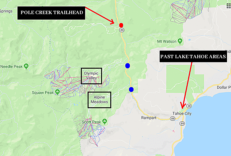
Here we will take a further look at the disappearance of Donna Lass from the Sahara Tahoe Hotel & Casino on September 6th 1970, attempting to discover the approximate area she was disposed of or buried. The last article on this subject pinpointed an area along California State Route 89 by Pole Creek Trailhead. The Zodiac Killer (if responsible for her murder) had previously made two phone calls to police, directing them to the crime scenes at Blue Rock Springs Park and Lake Berryessa. When the Pines Card was mailed on March 22nd 1971 it held directions within its design, such as "Sierra Club", "pass Lake Tahoe areas" and a punch-hole on the right side. The postcard was mailed to the San Francisco Chronicle and was addressing the police.
Here is a snippet from the South Lake Tahoe Police Department website: "The South Lake Tahoe Police Department (SLTPD) was formed July 1, 1967. The first home of the department was on the southwest corner of Lake Tahoe Boulevard at “D” Street. This is currently the present location of the City Corp. Yard. By the spring of 1969, SLTPD had 33 officers, seven civilian positions, and nine vehicles. We needed a bigger facility. So during the tenure of John Crow, the second Chief of Police at the helm of SLTPD, the Police Department moved to a month-to-month rental facility at Fremont Avenue and Mono Way. This structure is now the home of Nel’s Hardware store. This building was not constructed as a police facility, and eventually another move was needed. In April of 1973, the department moved to its current location in the El Dorado County Government Center, on Johnson Boulevard".
All three of these locations sit under the south side of the lake, so the instructions on the Pines Card to "pass Lake Tahoe areas" can only mean one of two things - the police needed to travel along the east side of the lake using US Route 50, towards Incline Village (the area depicted on the Pines Card), or travel along the west side of the lake, towards the Donner Memorial State Park and the Sierra Club at Clair Tappaan Lodge (also depicted on the Pines Card). See below.
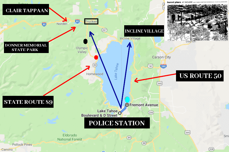
If the killer was living or vacationing on the south side of the lake, then he may very well have crossed paths with his target at the Sahara Tahoe Hotel & Casino, the Monte Verdi Apartments at 3893 Pioneer Trail (where Donna Lass lived), or somewhere close by. Whether he murdered Donna Lass first, then disposed of her body, or murdered her at the location he concealed her body, his most direct and convenient route of travel from the south side of the lake, is to "pass the Lake Tahoe areas" on the east or west side, via a major route. California State Route 89 and US Route 50 both skirt the lake on either side, and more importantly, head towards Incline Village and the Sierra Club at Clair Tappaan Lodge.
A newspaper article stated that 'the site depicted on the 'Pines Card' was from an advertisement published last Sunday by several newspapers. It was an artist's rendition of houses among the trees at a Boise Cascade Company project at Incline Village, where construction has just begun on the development. While much of the Sierra area is under several feet of snow, Incline Village has only two feet on the ground. Police went to the area to determine if a search is possible'. Chief Lauritzen added "There's no point to a search at this time. It's unlikely a victim would be uncovered before spring". This indicates that a search was to be initiated in this area, but it clearly failed to unearth the remains of Donna Lass. Parking your vehicle in the area of Incline Village under construction doesn't seem the most sensible choice to start digging a grave. When we consider that the July 13th 1971 Monticello Card revealed the name "Kathy" at the Oak Hill Memorial Park, and the Pines Card overlayed over the Sierra Club of Clair Tappaan Lodge revealed the name "Donna" (at the Donner Memorial State Park), it seems as though the Incline Village advertisement was used more as a template, rather than the actual burial site. The act of the Zodiac Killer adding "Sierra Club" to the postcard was clearly significant in this instance.
Using a sprinkling of geographic profiling and the words on the Pines Card, the Zodiac Killer would be "past the Lake Tahoe areas" at Tahoe City, where California State Route 89 breaks away from the lake. He now has to effectively bury Donna Lass between Tahoe City and the Donner Memorial State Park by Truckee. Is he going to risk performing this task by Alpine Meadows or Olympic Valley?, or travel to the much more secluded area by Pole Creek Trailhead, which is exactly mid-distance between Tahoe City and the Donner Memorial State Park - this is the first and logical choice to avoid detection. There are some other turn off areas in this region of California State Route 89 where the Zodiac Killer could have disposed of a body, but mid-distance in a secluded area and sitting under his crosshairs on the Pines Card overlay, seems as good as any.